-
 Plan your holidays
-
 What to do
-
 Where to eat
-
 Where to sleep
-
 Where to shop
-
 Ticket sale
-
 River access
-
 Agenda
 Routes and excursions
Where to eat
- Start
- »
- Where to eat


Routes and excursions TOP
-
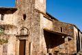
Romanesque hermitages of la Garrotxa
Although some structures from the 11th century do still stand, most of the surviving medieval buildings in La Garrotxa date from the 12th and 13th centuries.
-

Sant Feliu de Pallerols, Sant Pere Sacosta, el Far. Natural Park route 25
Long itinerary to El Far, one of the most important viewpoints of La Garrotxa, which, despite the great unevenness, is done smoothly and without much effort.
-
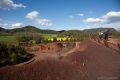
Croscat volcano. Natural Park route 15
The volcano of Croscat and its gredales are one of the jewels of the Natural Park of the Volcanic Zone of La Garrotxa. This itinerary will take you inside the youngest volcano in the Iberian Peninsula.
-

Sant Feliu de Pallerols - Les Planes d'Hostoles. Natural park route 21
Very simple route between Sant Feliu de Pallerols and Les Planes d'Hostoles following the old royal road.
-
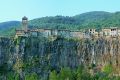
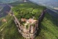
Castellfollit de la Roca cliff. Natural Park route 13
This itinerary passes near a spectacular basaltic cliff, not only for its height, but also for the houses built right on its edge.
-

Olot - Santa Pau. Natural Park route 3
This itinerary crosses the central area of La Garrotxa Volcanic Zone Natural Park, passing through places such as Moixina wetlands, La Fageda d'en Jordà, and the banks of the volcanoes Croscat and Santa Margarida.
-
Sant Pere Sacosta. Route 1 Les Planes d'Hostoles
The parish of Sant Pere Sacosta has the privilege of being one of the oldest and most remote inhabited villages of la Vall de Hostoles. Located on the slopes of la Serra del Puig del Moro, on the north ridge of el Far and below el Coll de Condreu.
-
From l'Hostalnou to Sta. Margarida de Bianya by la Torre de St. Pere. Ruta 4 Vall dels Sentits
Itinerary that takes us to the Romanesque church of Santa Margarida de Bianya, leaving from the small hamlet of Hostalnou de Bianya. Along the hike there are wonderful views of the Bianya valley.