-
 Plan your holidays
-
 Where to sleep
-
 What to do
-
 Where to eat
-
 Where to shop
-
 Ticket sale
-
 River access
-
 Agenda
-
 Search accommodation
 Routes and excursions
Where to eat
- Start
- »
- Where to eat


Routes and excursions TOP
-
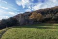

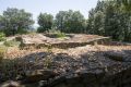
Sant Pere Sacosta. Route 1 Les Planes d'Hostoles
The parish of Sant Pere Sacosta has the privilege of being one of the oldest and most remote inhabited villages of la Vall de Hostoles. Located on the slopes of la Serra del Puig del Moro, on the north ridge of el Far and below el Coll de Condreu.
-
Saint James's way
The St James’ Way runs through the county of La Garrotxa and visits en route a number of interesting sites.
-
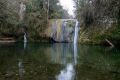
La Plana bathing pool. Route 3 Les Planes d'Hostoles
Les Planes d’Hostoles is well known for its natural bathing pools that have been used in numerous films and adverts. This is one of four suggestions.
-

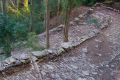
From Sant Pere Despuig to the Rovira bridge, passing by the Moli d'en Solà. Ruta 3 Vall dels Sentits
A walk through some ot the prettiest corners of the Vall de Bianya, following the course of the Santa Lucia river until reahing the Rovira bridge, apart from being able to visit the church of Sant Pere Despuig.
-
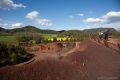
Croscat volcano. Natural Park route 15
The volcano of Croscat and its gredales are one of the jewels of the Natural Park of the Volcanic Zone of La Garrotxa. This itinerary will take you inside the youngest volcano in the Iberian Peninsula.
-
The balcony of Mieres. Route 1 Mieres
This route runs from Mieres towards Collet de la Devesa and Coll de Palomera. It was used by local people to go to the annual festivities up on Serra de Finestres.
-
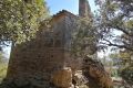
Sant Miquel de Coma-de-Roure route
In a small pass between the Borró valley and the Espinau valley, stands the small church Sant Miquel de Coma-de-Roure, located on top of the mountain of the same name with magnificent views.
-
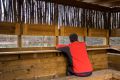
River route. Route 4 Argelaguer
Route to the wildlife watching hide, with a little luckyou will see birds such as Mallard , Grey Heron and Little Egret . The lucky few might just catch a glimpse of an Otter , reintroduced into the basing of the river Fluvià at the end of the 1990s.