If you enjoy going hiking, discovering new places with every step you take, experiencing new sensations and new challenges......If you want to rediscover nature in it purest state and contemplate the history of the country, in short, if you want to surprise yourself, come and discover Itinerànnia's network of paths.
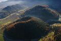
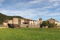
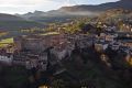
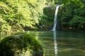
Itinerànnia is a network of more than 2,500 km of signposted hiking paths running through Ripollès, to La Garrotxa and the Alt Empordà: from the Pyrenees to the Mediterranean. You will be able to re-trace historic old pathways, see the high mountain, Romanesque hermitages, dormant volcanoes, medieval villages, coastal marshes....
Itinerànnia also offers various itineraries by some of the most interesting places in the region.
Use this site to plot your route through the network of trails Itinerànnia, and get the length of the footparh, the travel time, the minimum and maximum height, the distance in descent and ascent in plan, the profile ... all this information ready to print or ready to download to your GPS. In addition, you will find information on more than 700 points of interest.
You can also check specific routes. There are so many to choose from!
Have you found any sign that was missing? There was a tree that prevents the passage? Use this website to inform us of all incidents related to Itinerànnia. Thanks for your help!
Soon this service will also be available at Ripollès.
Itinerànnia in La Garrotxa
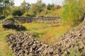
In La Garrotxa, Itinerànnia has more than 700 km of signposted paths, from the Alta Garrotxa to the Vall d'Hostoles, from Collsacabra to Besalú. Traditional paths, old drovers' trails, Mass paths...We are restoring the old communication routes between the region's villages for you and we present them laid out, accessible and signposted.
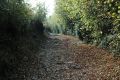
And while it's possible to reach almost any corner or little hamlet of the countryside by car, now you can also do it on foot. Just like a network of roads, through Itinerànnia you will be able to get to the most emblematic nooks of our land and discover places of great beauty and contrast. You will find a host of activities, restaurants and accommodation close to the paths, and be able to enjoy exquisite food from the area and take part in the activities that you most enjoy.
For us, hiking is about more than going on foot. It is more than just walking. It is about savouring the territory. It is about feeling nature and history. In short, for Itinerànnia the essence of hiking is to find and discover yourself.
Type of signals (markings)
The Itinerànnia network's signals are yellow. You have to follow the yellow rectangles. At crossroads where several of the network's paths meet, specific vertical signals will help you to get your bearings. At the crossroad between a network path and a non-network path, there will not usually be any vertical sign. Each pole will indicate the basic location information relating to it.
Maps and publications
A map of Itinerànnia is available. It is advisable to use the Itinerànnia network map to orientate and to consult the information boards that are found in all villages. Buy the map.
For best experience with smartphone or laptop, download Itinerànnia APP!