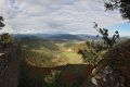
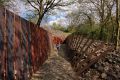
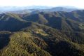
In addition to La Garrotxa Volcanic Zone Natural Park and L'Alta Garrotxa, La Garrotxa has other valuable natural areas, such as much of Milany-Santa Magdalena and Puigsacalm-Bellmunt mountain ranges, part of the Collsacabra and a small part of the Mountains of Rocacorba.
These three protected areas contain beautiful landscapes, roads full of history and spectacular viewpoints.
-
 Plan your holidays
-
 Where to sleep
-
 What to do
-
 Where to eat
-
 Where to shop
-
 Ticket sale
-
 River access
-
 Agenda
-
 Search accommodation
 Routes and excursions
Other protected areas of La Garrotxa
- Start
- »
- Territory and Nature
- »
- Natural Park and protected areas
- »
- Other protected areas of La Garrotxa


Routes and excursions TOP
-
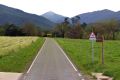

Sant Joan de les Abadesses to Vall de Bianya cycle path
Route between the Vall de Bianya greenway route and Sant Joan de les Abadesses.
-

Olot - Santa Pau. Natural Park route 3
This itinerary crosses the central area of La Garrotxa Volcanic Zone Natural Park, passing through places such as Moixina wetlands, La Fageda d'en Jordà, and the banks of the volcanoes Croscat and Santa Margarida.
-

Sant Feliu de Pallerols - Les Planes d'Hostoles. Natural park route 21
Very simple route between Sant Feliu de Pallerols and Les Planes d'Hostoles following the old royal road.
-
Sant Pere Sacosta. Route 1 Les Planes d'Hostoles
The parish of Sant Pere Sacosta has the privilege of being one of the oldest and most remote inhabited villages of la Vall de Hostoles. Located on the slopes of la Serra del Puig del Moro, on the north ridge of el Far and below el Coll de Condreu.
-
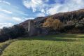
El Castellot de Beuda route. Route 1 Beuda
A fairly affordable route to Castellot, an old watch building 220 meters above Beuda.
-
RCR Arquitectes Route
A team of architects, RCR, has placed La Garrotxa at the forefront of architecture. Their unique skill of marrying the landscape and architecture has been rewarded by many different awards, including the prestigious Pritzker Prize (2017).
-
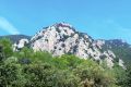
Montsacopa and Montolivet volcanoes. Route 3 Olot
This route visits two of Olot’s most remarkable volcanoes, Montsacopa and Montolivet.
-
Sant Iscle and Vallac valeys: volcanoes and castles. Natural Park route 19
This route allows you to discover one of the least known but most interesting areas of La Garrotxa Volcanic Zone Natural Park, walking between forests and farmhouses.