Classic hiking trail to the hermitage of Sant Aniol d'Aguja. Keep in mind that the route goes through an abrupt and wooded area without any type of services, sources, or mobile coverage.
Classical hiking trail to the hermitage of Sant Aniol d'Aguja. Keep in mind that the route goes through an abrupt and wooded area without any type of services, sources, or mobile coverage.
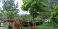
The excursion goes through different types of substrates (silicic and calcareous) and different formations (lowland holm oak, mountain holm oak, riverside forest, rock communities and scree). The flow of the stream is often intermittent, since the water infiltrates under the stream, it disappears and returns to appear further on.
From the town of Montagut, we will take the asphalted road to the Sadernes neighborhood. Nearby there is a fountain and the church of Santa Cecilia. During the season with the highest influx of visitors, there are restrictions for accessing vehicles from Sadernes: this is where we will begin the route.
We will begin the path descending along the track next to the church of Santa Cecília de Sadernes. We will walk along the track always following the orange and green marks, and also the yellow of Itinerànnia.
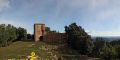
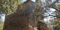
We pass by the bridge of the Pass of the Hails and immediately we will find an imposing rocam to the left where there are the ruins of the Sespasa castle. We will cross the river over a bridge without railings and we will reach the last parking area.
We will continue along the track until we find the G40 pont de Valentí's side of the Itinerànnia Trailers Network on the left. Here we find a sign that indicates the path of Sant Aniol to itinerary 1.
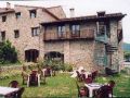
Crossing the bridge we arrive at the old Hostal de Ca la Bruta (currently restored); We turn to the right, we will find a point where two roads leave and we will take the one of more to the right that goes parallel to the river.
The path that we follow crosses the track that goes to the house of La Quera. At this point, we find a sign and wooden stairs that allow us to climb along the path that follows the itinerary.
Later, we will find a crossroads with the signal that indicates that you have to go down to find the path of Sant Aniol. At once we find some wooden steps that lead to the track of La Muntada, which will continue until we find a small car park where we will find a banner of the itinerary, which indicates the direction. We have to cross the parking lot and laugh it, and follow the trail that borders the stream until reaching the Gomarell lock.
At this point we find a new crossing that will continue until Sant Aniol until about 50 min.
We will pass the dam by the same top of the lock and follow a well-milled road that goes up the left bank until the Citron gorg, where we will cross the stream. Shortly thereafter, we will have to cross the stream again by a walkway and continue along the left bank until reaching a crossroads, the hill of El Molí de Sant Aniol. We will take, as indicated by the banner, the path that goes to the left towards the mill of Sant Aniol. At this point we also started to find the GR11 brands.
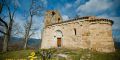
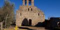
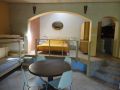
We will take a fourth step on the stream (for a new suspension bridge), just behind the hermitage of Sant Aniol. Next to the hermitage there is the rectory and the fountain.
We find a new indicator, and from here we can go to the salt of Brull, taking the path that goes from the source to the right, always following the green marks and oranges. It takes about 40 minutes (round trip).
The return to Sadernes is proposed by the jump of the Bride, in the direction indicated from the source. Throughout this stretch until the turning off of La Muntada, we will also find the yellow markings of Itinerànnia and those of the GR11.
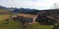
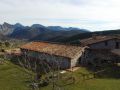
At the beginning we will cross the Can Barrufa ridge and, later on, we will pass to the right of the ruin of ca l'Abat. We are walking until the path begins to climb firmly. After a while we arrive at the port of La Guilla and soon we will have a perfect view of the headwaters of the Sant Aniol valley.
We will reach two viewpoints of the valley: the Vicarius' jump and then the splendid salt of the Bride. At this point you have to be careful, as this is a narrow pass with an important vertical difference.
A little further on we will find the G36 crossing of Itinerànnia and continue towards Sadernes, and we will leave the GR11 that leads to Talaixà. This trail drops strongly in zigzag until the Gomarell lock.
At the point where we find the crossing of the Mount, we will continue towards Sadernes, along the same path: there is about 1h 40 min to reach our destination.
IN THE CASE OF CRESCUDES, THE OUT OF THE SECTOR OF SANT ANIOL IS ONLY POSSIBLE BY THE SALT DE LA NÚVIA.
Do you need or prefer to be accompanied by a guide? Check the list of environmental and cultural guide companies.
To access the Sadernes car park, it is essential to make a reservation at certain times of the year.