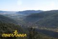
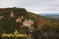
Very long route, demanding and very uneven by some of the most unique places of the Alta Garrotxa.
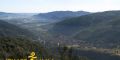
The excursion, due to the important unevenness that we accumulate, allows us to observe from the lowland holm oaks, with shrubs adapted to live in rather dry and warm places, to the mountainous holm oak, accompanied by a large amount of pi roig; And we can also see, amongst them, the chestnuts of La Plana, which develops in a more acidic soil.
From the town of Montagut, we will take the asphalted road to the Sadernes neighborhood. Nearby there is a fountain and the church of Santa Cecilia. During the season with the most influx of visitors there are restrictions for the access of vehicles from Sadernes: this is where we will begin the route.
We will begin the path down the track next to the church of Santa Cecília de Sadernes.
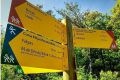
We will walk along the track always following the orange and green marks, and also the yellow of Itinerànnia.
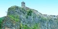
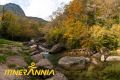
We pass by the bridge of the Pass of the Hails and immediately we will find an imposing rocam to the left where there are the ruins of the Sespasa castle. We will cross the river over a bridge without railings and we will reach the last parking area.
We will continue along the track until we find the G40 pont de Valentí's side of the Itinerànnia Trailers Network on the left. Here, we find a sign that indicates the direction of Route 5 towards Bassegoda.
We continue climbing the track and, about 150 meters, we will leave it to take a path that goes to the right. The path goes up and up and we get raised quickly. We will leave to the left a path that leads to the base of the cliff and, after crossing a crust, we will reach Queret.
The path continues to climb until you find a crossing that will continue to the left. At the next crossroads we will also go to the left, and to the Sant Feliu de Riu sights.
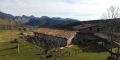
After Sant Feliu de Riu, we will find the track that goes up from Sadernes and we will follow it to the right. After just over ten minutes, we arrive at a crossroads: we will continue straight on to enter the castanet de la Plana. We will leave a track to the right and arrive at the Masia de la Plana: we cross some meadows until we reach another crossroads. We climb the track on the right across the chestnut tree of Ca n'Agustí. After crossing the chestnut tree, we will continue up the track until we find a road to the left, which later becomes a path and leads us to the ruins of the Vinardell house, in a small hill. The road continues to ascend, we pass by a second collet and a steep climb that makes zigzags for a holm oak, and we arrive at the hermitage of Our Lady of Needles.
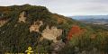
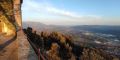
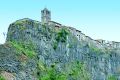
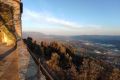
To the left of the hermitage, we find the path that climbs up the forest and we will continue towards the west. We leave to the right a path that leads to the River Neck and, just over five minutes on our way, we reach another crossroads where we take the path on the right which rises steeply until reaching the corner of Comadells. Without taking a step away from us, we make the toughest part of the ascent and arrive under the cliff of the Bassegoda hill: we will go down the side of the saddle, following the foot of the cliff. We will arrive to the other side of the base of the summit where we expect a short climb up to the top.
Undo the last cliff and, at the base of the cliff, we follow the descent to the left. The path goes down to the Battery Plane. Here we find a track that will continue descending and that will take us after a few revolts to link with the main track that comes from the Bassegoda pass and goes to Ribelles and the Hostal de la Muga. At this point the path also coincides with that of the GR11. We will go to the left and immediately we will be at the beginning of the neck.
Just below the ruins of the Principio farmhouse, we continue to the right along a track. One hundred meters later, we leave the track and start the path that will take us to Principi. After the house, the path goes down until you cross the torrent and continues a few meters up until we find a crossroads: we continue straight until we get to Coll Roig. From here, a long descent will take us to La Comella stream. Then we will reach the crossroads of Sant Aniol d'Aguja, we will leave the GR11 and continue down to the left. We cross the Sant Aniol stream and follow the path that follows the course of the stream to Gomarell.
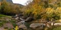
We are on the plain of La Muntada and the road follows first by a very damaged track, to return to take a path that passes near the river and, after crossing it, arrives at a small parking lot just next to the track , which we continue to the left in the direction of Sadernes. Before five minutes we leave the track and continue along the path that goes to the right and leads us to the bridge of Valentí.
Do you need or prefer to be accompanied by a guide? Check the list of environmental and cultural guide companies.
To access the Sadernes car park, it is essential to make a reservation at certain times of the year.