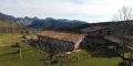
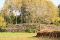
The excursion goes through the dominions of the oak wood, the beech grove and the mountain meadows, and also aims to reach two of the highest and most emblematic peaks of the Alta Garrotxa.
The excursion goes through the dominions of the oak wood, the beech grove and the mountain meadows, and also aims to reach two of the highest and most emblematic peaks of the Alta Garrotxa. For a good part of the journey, they enjoy beautiful views of this space.
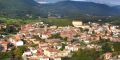
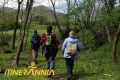
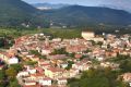
To do this excursion we will need to first approach us to Beget, accessible village from Camprodon (for Rocabruna) or from Castellfollit de la Roca (for Oix). The path begins at the ponds of Monars, where we can reach the track of the Bassa de Monars by 4x4, which begins at a turnoff to the right a few kilometers after Beget, in the direction of Rocabruna; To recognize the break, you should note that a few meters above the track there is a water tank.
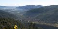
At the lowlands of Monars we start the ascent to the Comanegra as indicated by the start arrow: we will reach a lower peak marked with an iron cross and continue climbing to the top that is indicated by a geodesic vertex. From here we can get a good panoramic view, especially to the south.
We will descend from the Comanegra on the other side, and close to the summit we will find some beech trees that are very thick and branched. We will descend decisively (or in short ziga-zagues) and we will enter the beech forest of the Baga de Bordellat; the path goes through the ridge and stands in the direction of the Comanegra.
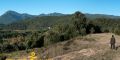
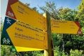
We will arrive to the plain of the Pla de la Serra, which divides the Garrotxa and the Alt Empordà, where we will find an indicator, and we will continue towards the peak of the Sorceresses. In this section, in addition to the green and orange brands, we will find the yellow ones of the Itinerànnia Senders Network.
We will set aside some path that goes down the shade towards the Coll de les Falgueres and we will follow the signs.
Further on, the path opens towards the southwestern slope, towards the banks of Monars, below the same ridge, occupied by rocks. Further on, the path leads to the obac side, and we will enter a beech forest.
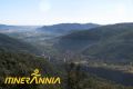
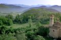
When leaving the forest, we will pass through the ridge again, at the Donantic hillside, the lowest point in the ridge, and following it we will find a rocky rock that flank to the right. Further on we will reach another rock, finally reaching the peak of the Witches (or Caburlé). From the summit there is a good panoramic view of Ribelles, Monars and Hortmoier.
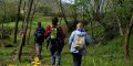
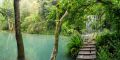
We will descend from the peak of the Witches towards the Colladas: the path takes an elbow and tombs to the right. We will find a signal that we will follow in the direction of the ponds of Monars.
We will follow the orange and green marks, we will go down a meadow and we will find a tree from time to time. At the end of the descent, we will find some troughs for livestock. We will go up gently for meadows until crossing a forest, and we will pass by the head of Malpàs until reaching the collar of L'Orri, where we will find an indicator that goes to the ponds of Monars. Here we leave the path and take a track until reaching the ponds, again.
Do you need or prefer to be accompanied by a guide? Check the list of environmental and cultural guide companies.