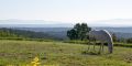
Maià de Montcal is the municipality situated at the easternmost extreme of La Garrotxa, right on the boundary with the Alt Empordà and the Pla de l'Estany.
The Fluvià cuts through the south of the area, which is also watered by the Maià and Segueró rivers before they flow into the Fluvià at Dosquers.
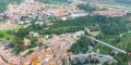
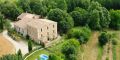
The area's residents are spread among various settlements: el Quer, les Ferreries, Dosquers, Bruguers, Jonqueres, Llorenç and Pocafarina.
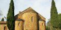
In Maià de Montcal there is the church of Sant Vicenç, dating from 978. It boasts a rectangular nave and a circular east-facing apse and singular ironwork on the church door. Santa Magdalena de Maià (13th century), the former church of the old priory of Santa Maria de Jonqueres (13th century), located at the eastern limit of la Garrotxa on the top the hill of Santa Magdalena. It has a barrel roof and an apse with a quarter barrel roof.
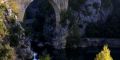
Sant Martí (12th century) in the hamlet of Dosquers, which boasts a single nave with a barrel roof and a semi-circular apse. The chapel of Saint Prim and Saint Felicià, along with a generous natural spring that, according to legend, provided water for those carrying the remains of the saints to the monastery of Saint Pere in Besalú.