La Garrotxa has two distinct types of plant landscape: the Mediterranean, characterized by the presence of holm, and the Atlantic Central European, with oak and beech trees of various species. Regarding the flora, only in La Garrotxa Volcanic Zone Natural Park has there are more than 1,170 species of higher plants and several rare plants in Catalan flora.
This diversity of environments present in La Garrotxa coexists with a very diverse fauna and contains species of great interest, especially invertebrates. In La Garrotxa Volcanic Zone Natural Park know there are nearly 300 different species of vertebrates, 52 of which are mammals, 198 birds, 13 amphibians, 18 reptiles and 11 fish. As for invertebrates, there are more than 164 registered non-arthropod invertebrate species, 20 arthropods and insects not more than 1,000 insects.
-
 Plan your holidays
-
 Where to sleep
-
 What to do
-
 Where to eat
-
 Where to shop
-
 Ticket sale
-
 River access
-
 Agenda
-
 Search accommodation
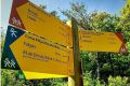
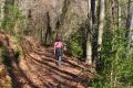
 Routes and excursions
Flora and fauna
- Start
- »
- La Garrotxa
- »
- Territory and Nature
- »
- Flora and fauna

Routes and excursions TOP
-

El Mont from Segueró route. Ruta 4 Beuda
Route of 6.4 km the church of the Sanctuary of late Romanesque style, from the beginning of the 14th century.
-
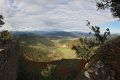
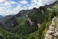
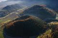
Summits of La Garrotxa
Discover some of the nest natural viewpoints in La Garrotxa and all provide incredible panoramas.
-
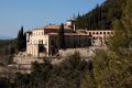
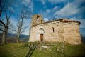
Climb to Mare de Déu del Mont from Beuda. Route 2 Beuda
Walking route to Virgen del Monte, the church of late Romanesque style Sanctuary, dated from the beginning of 20th century.
-

Route Ribelles and Sant Aniol (from Hostal de la Muga)
The church of Sant Julià de Ribelles is Romanesque and was consecrated in 947. Sant Aniol d’Aguja dates from the High Middle Ages and was a Benedictine monastery before being transformed into a parish church and sanctuary.
-

Sant Feliu - coll d'Úria - La Salut. Natural Park route 28
Itinerary for the Health Shadow, with a significant drop, but with a reward in the form of panoramic views over the Brugent river valley and much of the Natural Park.
-
Circular route Mare de Déu del Mont Half Marathon (MdM)
High difficulty route, 20,6 KM and ascent of 1605 m
-
GR 11 - Cross-Pyrenean trail
This route follows the southern flank of the Pyrenees from the Bay of Biscay to the Mediterranean. Difficult high-altitude sections give way to peaks, valleys, villages, forests and ridges in a varied landscape of great visual beauty.
-
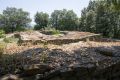
The two castles route. Route 6 Santa Pau
anta Pau Castle stands in the middle of the village of Santa Pau, which was once enclosed by a series of walls and fortifications. In the fifteenth century, a ‘new’ quarter was built at the entrance to the gate that provides access to the arched squares.
-

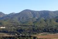
Circuit of the cliff of Rocalba. Route 1 Sant Feliu de Pallerols
The Rocalba cliff is an excellent viewpoint over Sant Feliu de Pallerols. The holm and downy oaks take over the forest, but one can also find other species that grow randomly like poplars, willows, chestnuts and cherry trees.
-
The balcony of Mieres. Route 1 Mieres
This route runs from Mieres towards Collet de la Devesa and Coll de Palomera. It was used by local people to go to the annual festivities up on Serra de Finestres.
-
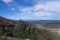
Sant Miquel del Mont, a viewpoint over la Vall de Bianya. Ruta 5 Vall dels sentits
A circular walk that provides spectacular views of L’Alta Garrotxa and the Pyrenees as it passes through woods of ancient oaks.
-
From Sant Pere Despuig to the Rovira bridge, passing by the Moli d'en Solà. Ruta 3 Vall dels Sentits
A walk through some ot the prettiest corners of the Vall de Bianya, following the course of the Santa Lucia river until reahing the Rovira bridge, apart from being able to visit the church of Sant Pere Despuig.