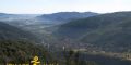

This route offers an alternative way of discovering three of the most-visited places in La Garrotxa Volcanic Zone Natural Park.
The path from the Santa Margarida car-park heads northwards across the road (GI-524, Olot-Santa Pau) and then coincides with Natural Park itinerary 15 (Grederes del Croscat) as far as the turn-off to Can Passavent.
The volcano Croscat
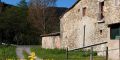
Croscat is a Strombolian volcano and its 160 m in height make it the highest volcanic cone in the Iberian Peninsula. For many years one of its flanks was quarried and today an impressive scar – that can be visited by following itinerary 15 – remains as a reminder of the once active quarry (gredera). This a very fragile site and visitors should not leave the marked paths. On the flanks of the volcano stands Can Passavent Information Centre, where there is a permanent display about the restoration of the volcano. After contouring around the former municipal rubbish tip (now closed and sealed), the path drops gently to the car park at Can Serra. At Can Serra, the itinerary crosses under the road and takes you down a short flight of steps into the Fageda d’en Jordà.
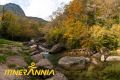
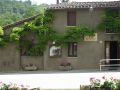
The Fageda d'en Jordà
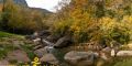
The famous Fageda d’en Jordà is a beech forest growing at low altitude (550 m) upon the rugged undulating lava flow emitted by the volcano Croscat, which is characterised by numerous scattered lumps and hummocks (known as tossols) that in some cases are over 20 m high.
After leaving the Fageda, the path takes you onto Coll de Can Batlle and Sant Miquel Sacot, the latter a church of Romanesque origin dating from the 11th century. From here, it drops down to Pla de Sacot and then climbs up to Collet de Bassols on the south-west flank of the volcano of Santa Margarida.
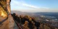
The volcano Santa Margarida
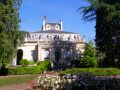
Santa Margarida is a freato-magmatic volcano, whose explosion opened up a wide circular crater in whose midst stands today the eponymous Romanesque church. In the case of Santa Margarida, the explosion opened a broad circular crater in which the chapel dedicated to Santa Margarida was built. Today, the crater floor is pastureland, while the flanks of the volcano are covered in evergreen holm oak on the sunny south-facing side and mixed deciduous forest on the cooler north-facing slopes. From here this itinerary continues onto the car-park at Santa Margarida, a section that links to Itinerary 3 (Can Xel-Santa Pau).
To enjoy this route to the full, we recommend that you visit in spring, summer or winter, since the autumn colours attract large numbers of visitors to this part of the Natural Park.
Don’t miss
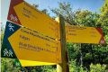
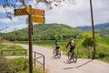
·The other walking itineraries that link up with this route: Natural Park itinerarie 3 (Olot-Can Xel) and the marked paths of the Itinerànnia network, which provide access to many more interesting places in the La Garrotxa, both in and outside the Natural Park.
·The Bosc de Tosca and, more specifically, the Pedra Tosca Park in Les Preses, is a unique rural landscape of great ecological interest. It stands on the lava flow emitted by the volcano Croscat and one of its most outstanding features are its extraordinary dry-stone walls.
·The traditional gastronomy of la Garrotxa in the restaurants of the group Cuina Volcànica.
Did you know?
·Groups who visit Croscat must have made a reservation (Tel.: 972 19 50 94) and be accompanied by an accredited Natural Park guide, or have received authorisation from the Natural Park (Tel.: 972 26 81 12).
·Another point of interest on this route is the Romanesque church of Sant Miquel Sacot (11th century).
·The spring at Collelldemunt (not drinking water) in the Santa Margarida car-park is the only source of drinking water on the whole route.
Route Details
·Max. height: 744 m Min. height: 568 m
·Total climb: 199 m
·Total descent: 190 m
·Distance: 11 km aprox.
·How: on foot. Mountain bikes and horses are not allowed on this itinerary
·How to get there: by car, take the GI-524 from Olot to Santa Pau
·Duration: half day
·Difficulty: moderate
·Starting point: Santa Margarida car-park
·Signposted? Natural Park itinerary 1 and in part the Itinerànnia network
More information
·Tourist map of La Garrotxa.
· Do you need or prefer to be accompanied by a guide? Check the list of environmental and cultural guide companies.