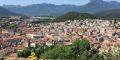
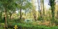
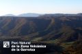
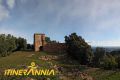
The itinerary starts at the Santa Pau bridge parking lot. We go to the center of the village and leave the streets of Les Cases Velles. We descend through the orchards to the bridge of Instincts. We pass below Can Pujol and Can Bellaguarda. Here we find a track and a path to the left and we will go to Santa Maria dels Arcs. The itinerary crosses the football field (bus parking lot) and goes to a road. In a few meters you turn right along the Can Pratdavall oak grove. After passing the trail, a path to the right leads us to the Can Rosta pass.
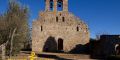
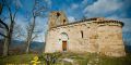
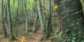
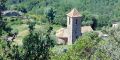
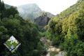
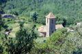
When arriving at the farm, you have to skirt it behind the road and we will come to a trail that will take us to Can Esparregueres (where we can see monumental holm oaks). We arrive at the Mieres road, cross the bridge and turn left onto a small track. We pass a fountain and we cross the river to a walkway, cross it and head towards Sant Vicenç de Sallent. We passed behind the church and left on the road.
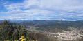
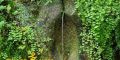
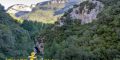
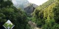
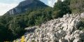
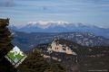
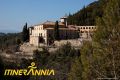
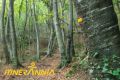
We find the entrance to the Rocacorba farm and follow the street that will descend us to a bridge. The itinerary continues along a path to the left of the bridge (section shared with the GR-2) that passes below Can Batlle and until the jump of the same name. We climb the path past and past Can Formiga we can see the stone of the Devil in a meadow on our right. The path returns to cross the river, we find sources until the break of Sant Martí Vell. Here we have the option to go straight or turn right to get to the hermitage. We go back to cross the river and go up to Santa Pau reaching the Mieres road. It is worth it (despite being circular) to do it in this sense to avoid the unevenness.
-
 Plan your holidays
-
 What to do
-
 Where to eat
-
 Where to sleep
-
 Where to shop
-
 Ticket sale
-
 River access
-
 Agenda
-
 Search accommodation
 Routes and excursions
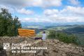
Santa Pau - Santa Maria dels Arcs - el Sallent. Route 14 Parc Natural
- Start
- »
- Routes and excursions
- »
- Santa Pau - Santa Maria dels Arcs - el Sallent. Route 14 Parc Natural

Information
Duration:
3h 25min
-
Nearby municipalities:
Type:
At your leisure
Type:
On foot
Area:
Nature
Difficulty:
Medium
Related routes and excursions
-


Sant Feliu - coll d'Úria - La Salut. Natural Park route 28
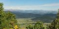
Itinerary for the Health Shadow, with a significant drop, but with a reward in the form of panoramic views over the Brugent river valley and much of the Natural Park.
-
Montsacopa and Montolivet volcanoes. Route 3 Olot
This route visits two of Olot’s most remarkable volcanoes, Montsacopa and Montolivet.
-
Circuit of the cliff of Rocalba. Route 1 Sant Feliu de Pallerols
The Rocalba cliff is an excellent viewpoint over Sant Feliu de Pallerols. The holm and downy oaks take over the forest, but one can also find other species that grow randomly like poplars, willows, chestnuts and cherry trees.
-
Besalú circuit. Ruta 1 Garrotxa
A route that brings to life the Romanesque treasures of the village of Beuda, and which can be complemented with a visit to the centre of Besalú.
-
Sant Miquel del Mont, a viewpoint over la Vall de Bianya. Ruta 5 Vall dels sentits
A circular walk that provides spectacular views of L’Alta Garrotxa and the Pyrenees as it passes through woods of ancient oaks.
-
La Moixina route. Route 6 Olot
Signposted route for the race of the Moixina race throughout the year.
-
The charcoal makers route. Route 2 Mieres
This route follows some of the old paths and trails used to bring wood charcoal down from the Serra de Finestres. The path that passes by Font Ricard is an attractive mule trail that connects the hamlet of Ruïtlles to the church of El Freixe.
-
Grau d'Escales route. Route 2 Montagut i Oix
Grau d'Escales is a relatively easy pass (grau = ‘pass’ and escala = ‘step’ in Catalan) between two abrupt cliffs from where there are good views of the Salt dels Lliberals (Liberal’s Leap).
-
Along the old monks’ paths. Route 2 Santa Pau
-
Sadernes - Sant Aniol d'Aguja. Route 1 Consorci Alta Garrotxa
Classic hiking trail to the hermitage of Sant Aniol d'Aguja. Keep in mind that the route goes through an abrupt and wooded area without any type of services, sources, or mobile coverage.
-
Vayreda’s Alta Garrotxa. Route 8 Garrotxa
Marian Vayreda’s novel La Punyalada provides one of the best ways of discovering the Alta Garrotxa. The places depicted by this 19th century author in the scenes from his famous novel have been joined in a discovery route.
-
El Mont. Route 4 Consorci Alta Garrotxa
Demanding route through the summits that surround the Mare de Déu del Mont, with panoramic views of much of the Garrotxa and the Alt Empordà.
-
Torre de Murrià route. Route 5 Les Preses
Torre de Murrià is a Roman watchtower that was converted into a signalling tower during the Carline Wars. It is reasonably well conserved and its moat and walls can still be seen.
-

Parc de Pedra Tosca. Route Olot 4
This easy walk is perfect for the whole family. You pass along the Carrilet, the former train line to Girona that acts as a reminder of Olot’s rich industrial past. Further on you visit El Parc de Pedra Tosca.
-
Coll de Bas - Marboleny -Castell de Colltort - Fontpobra. Natural Park route 26
The route will take us along the watershed between the river basins Fluvià and Brugent, tributaries of the river Ter, and will take us to one of the great viewpoints of the Natural Park: the castle of Colltort.
-

Can Xel - castell de Colltort - Fontpobra - Can Xel. Natural Park route 5
-

El Mont from Segueró route. Ruta 4 Beuda
Route of 6.4 km the church of the Sanctuary of late Romanesque style, from the beginning of the 14th century.
-
Fageda Fosca route. Route 5 Santa Pau
Hiking excursion to a beech tree hidden in the shadow of the Finestres mountain range.
-

Route Santa Bàrbara de Pruneres
Santa Bàrbara lies in the heart of L'Alta Garrotxa and affords memorable views over the Oix valley and the mountains of Bassegoda and El Ferran.The church dates from the twelfth or early thirteenth century, although it is likely that a primitive church.
-
La Miana route itinerary. Route 1 Sant Ferriol
This is a very long circular route that allows you to reach La Miana and return via a different path. If we want to do shorter sections to Sagrat Cor, Sant Silvestre el Mor, Sant Fructós, etc... you can do a round trip route.
Related resources
-
Centre Cívic Cal Fuster - Can Blanc
-

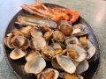
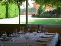
Restaurant Santa Margarida
-
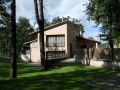
Can Salgueda apartments
-

La Francesa apartments
-

Cal Cisteller apartments
-

Can Passavent Information Centre
-

Can Xel apartments
-

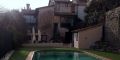
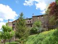
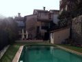
Mas Prat de la Plaça country house
-

Santa Pau Tourist Office
-
Can Pere Petit apartments
-
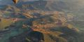
Vol de Coloms
Balloon flights over the volcanoes of Catalonia in la Garrotxa volcanic zone natural park
-

La Francesa restaurant
-

Naturatours
-
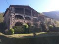
Mas el Carrer country house
-
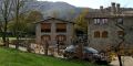
Hotel Cal Sastre
-

La Fageda Fundació
-

Centre Cívic Santa Pau
-

Pizzeria Gasparic
-

Can Xel restaurant
-

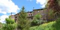
Mas Can Batlle country house
Related routes and excursions
-
Sant Feliu - coll d'Úria - La Salut. Natural Park route 28
Itinerary for the Health Shadow, with a significant drop, but with a reward in the form of panoramic views over the Brugent river valley and much of the Natural Park.
-
Montsacopa and Montolivet volcanoes. Route 3 Olot
This route visits two of Olot’s most remarkable volcanoes, Montsacopa and Montolivet.
-

Circuit of the cliff of Rocalba. Route 1 Sant Feliu de Pallerols
The Rocalba cliff is an excellent viewpoint over Sant Feliu de Pallerols. The holm and downy oaks take over the forest, but one can also find other species that grow randomly like poplars, willows, chestnuts and cherry trees.
-
Besalú circuit. Ruta 1 Garrotxa
A route that brings to life the Romanesque treasures of the village of Beuda, and which can be complemented with a visit to the centre of Besalú.
-

Sant Miquel del Mont, a viewpoint over la Vall de Bianya. Ruta 5 Vall dels sentits
A circular walk that provides spectacular views of L’Alta Garrotxa and the Pyrenees as it passes through woods of ancient oaks.
-

La Moixina route. Route 6 Olot
Signposted route for the race of the Moixina race throughout the year.
-

The charcoal makers route. Route 2 Mieres
This route follows some of the old paths and trails used to bring wood charcoal down from the Serra de Finestres. The path that passes by Font Ricard is an attractive mule trail that connects the hamlet of Ruïtlles to the church of El Freixe.
-
Grau d'Escales route. Route 2 Montagut i Oix
Grau d'Escales is a relatively easy pass (grau = ‘pass’ and escala = ‘step’ in Catalan) between two abrupt cliffs from where there are good views of the Salt dels Lliberals (Liberal’s Leap).
-
Along the old monks’ paths. Route 2 Santa Pau
-
Sadernes - Sant Aniol d'Aguja. Route 1 Consorci Alta Garrotxa
Classic hiking trail to the hermitage of Sant Aniol d'Aguja. Keep in mind that the route goes through an abrupt and wooded area without any type of services, sources, or mobile coverage.
-

Vayreda’s Alta Garrotxa. Route 8 Garrotxa
Marian Vayreda’s novel La Punyalada provides one of the best ways of discovering the Alta Garrotxa. The places depicted by this 19th century author in the scenes from his famous novel have been joined in a discovery route.
-
El Mont. Route 4 Consorci Alta Garrotxa
Demanding route through the summits that surround the Mare de Déu del Mont, with panoramic views of much of the Garrotxa and the Alt Empordà.
-
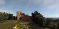
Torre de Murrià route. Route 5 Les Preses
Torre de Murrià is a Roman watchtower that was converted into a signalling tower during the Carline Wars. It is reasonably well conserved and its moat and walls can still be seen.
-

Parc de Pedra Tosca. Route Olot 4
This easy walk is perfect for the whole family. You pass along the Carrilet, the former train line to Girona that acts as a reminder of Olot’s rich industrial past. Further on you visit El Parc de Pedra Tosca.
-
Coll de Bas - Marboleny -Castell de Colltort - Fontpobra. Natural Park route 26
The route will take us along the watershed between the river basins Fluvià and Brugent, tributaries of the river Ter, and will take us to one of the great viewpoints of the Natural Park: the castle of Colltort.
-

Can Xel - castell de Colltort - Fontpobra - Can Xel. Natural Park route 5
-
El Mont from Segueró route. Ruta 4 Beuda
Route of 6.4 km the church of the Sanctuary of late Romanesque style, from the beginning of the 14th century.
-
Fageda Fosca route. Route 5 Santa Pau
Hiking excursion to a beech tree hidden in the shadow of the Finestres mountain range.
-

Route Santa Bàrbara de Pruneres
Santa Bàrbara lies in the heart of L'Alta Garrotxa and affords memorable views over the Oix valley and the mountains of Bassegoda and El Ferran.The church dates from the twelfth or early thirteenth century, although it is likely that a primitive church.
-
La Miana route itinerary. Route 1 Sant Ferriol
This is a very long circular route that allows you to reach La Miana and return via a different path. If we want to do shorter sections to Sagrat Cor, Sant Silvestre el Mor, Sant Fructós, etc... you can do a round trip route.
Related resources
-
Centre Cívic Cal Fuster - Can Blanc
-

Restaurant Santa Margarida
-
Can Salgueda apartments
-

La Francesa apartments
-
Cal Cisteller apartments
-

Can Passavent Information Centre
-

Can Xel apartments
-
Mas Prat de la Plaça country house
-

Santa Pau Tourist Office
-
Can Pere Petit apartments
-
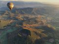
Vol de Coloms
Balloon flights over the volcanoes of Catalonia in la Garrotxa volcanic zone natural park
-
La Francesa restaurant
-
Naturatours
-
Mas el Carrer country house
-
Hotel Cal Sastre
-

La Fageda Fundació
-

Centre Cívic Santa Pau
-

Pizzeria Gasparic
-

Can Xel restaurant
-

Mas Can Batlle country house